In the evolving landscape of real estate, buyers and sellers alike increasingly value transparency and depth of information. Among the tools that are reshaping how market participants engage with properties, MLS overlays stand out as a sophisticated but sometimes underappreciated resource. Specifically, overlays that showcase historical land use data present an opportunity to enrich property listings with context that goes beyond mere square footage or number of bedrooms. This article examines the role of MLS overlays in illustrating historical land use, their significance in real estate transactions, and how professionals can leverage this capability to better serve clients.
Understanding MLS Overlays and Their Functionality
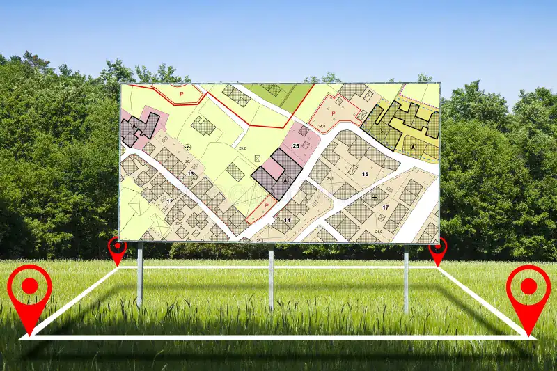
Multiple Listing Services (MLS) have long served as the backbone for the real estate industry, providing a centralized database of available properties. Over time, these platforms have integrated more dynamic features. An overlay refers to an additional layer of information placed atop a standard base map, offering visual representations of specific data points on or around property locations.
When applied to land use, overlays can reveal how particular parcels have been utilized over time. This may include past zoning classifications, prior agricultural or industrial uses, historical development patterns, or the presence of environmental features such as wetlands or protected areas. By superimposing this information onto the current map of listings, MLS overlays provide a richer narrative about each property’s place within the broader community fabric.
The Value of Historical Land Use in Real Estate Decisions
Understanding a property’s historical context is essential for several reasons. Buyers seeking to invest in residential or commercial real estate gain insight into potential benefits or risks associated with the site. For example, a parcel that was formerly used for industrial purposes may entail soil contamination concerns that necessitate further environmental inspection. Conversely, knowledge of longstanding agricultural use might appeal to clients wanting a connection to rural heritage or open space.
Sellers also benefit by transparently sharing the historical background of their land. This openness can build buyer confidence and minimize surprises that might otherwise stall negotiations or cause appraisal challenges. Additionally, highlighting unique historical aspects, such as former estate grounds or noteworthy past ownership, can serve as a distinctive marketing angle that adds intangible value.

Integrating Historical Land Use Into MLS Listings
The integration of historical land use data into MLS platforms typically requires collaboration between real estate professionals, local governments, and geographic information system (GIS) specialists. Municipalities frequently maintain archives of zoning maps, land records, and environmental assessments that can be digitized and layered for public and industry use.
Once incorporated into the MLS via overlays, this data becomes accessible to agents and their clients throughout the property search process. Agents can visually showcase historical boundaries, point out restrictions imposed by legacy land designations, and highlight features that may affect future development potential.
Moreover, MLS overlay tools often allow users to customize their map views, toggling between present-day zoning and past land use to observe changes over time. This temporal aspect is particularly helpful for evaluating neighborhood evolution, infrastructure improvements, and shifting regulatory priorities.
Environmental and Regulatory Considerations
Historical land use information provides critical clues regarding environmental conditions that might otherwise remain hidden until late stages in a transaction. For example, former use as a landfill, chemical plant, or waste disposal site can impose significant remediation obligations and affect financing opportunities.
Local regulatory bodies may impose restrictions or require disclosures based on historical findings. Properties in floodplains, near wetlands, or within historic districts often demand specific adherence to building codes or preservation standards. MLS overlays that highlight such constraints empower buyers and agents to factor regulatory compliance into their evaluations early on.
Furthermore, awareness of historical land use encourages due diligence practices such as environmental site assessments, preserving neighborhood character, and anticipating potential development challenges. By fostering proactive inquiry, MLS overlays reduce risks and enhance transaction smoothness.
Marketing with Historical Context in Mind
Real estate listings that include historical land use overlays stand out by offering clients a holistic view of the property’s story. Storytelling constitutes a powerful marketing tool, and the historical narrative surrounding a piece of land can evoke emotional connections, nostalgia, or aspirations.
For developers and investors, understanding past land uses aids in reimagining spaces while respecting cultural or environmental legacies. Heritage-conscious buyers may prefer homes situated on historically designated sites or in growth areas that reflect planning decisions.
To capitalize on this, agents can incorporate historical insights into listing descriptions, digital presentations, and open house materials. Multimedia tools that combine maps, photos, and contextual text enrich the buyer’s experience and increase perceived value.
Challenges in Utilizing MLS Historical Overlays
Despite the advantages, there are challenges associated with the use of MLS overlays focused on historical land use. Data completeness and accuracy can vary widely by jurisdiction, potentially leading to gaps or outdated information. Seamless integration of GIS data into MLS software requires ongoing collaboration and technical investment.
Moreover, interpreting historical land use requires expertise to avoid misrepresentation or undue alarm. Agents must balance providing comprehensive details with guidance, ensuring clients understand implications without unnecessary concern.
Privacy concerns also emerge, particularly when overlays reveal sensitive information about previous ownership or environmental hazards. Careful adherence to legal standards and ethical practices governs what data can be shared publicly.
Best Practices for Real Estate Professionals
To maximize the benefits of MLS overlays featuring historical land use, agents should cultivate a strong working relationship with local planning departments and GIS teams. Gaining access to reliable, up-to-date data enables informed consulting.
Professionals are encouraged to educate themselves about common land use histories in their market, including legacy industrial sites, former farmland, or notable urban developments. Sharing this knowledge with clients positions agents as trusted advisors invested in thorough evaluations.
During property showings and discussions, highlighting overlay visuals can clarify complex concepts and facilitate transparent conversations about potential opportunities or limitations.
Additionally, agents should always recommend professional inspections, surveys, or legal reviews when historical land use raises questions. This layered approach protects all parties and enhances confidence.
Future Trends and Innovations
The future of MLS overlays is poised for innovation as technology advances. Integration of augmented reality (AR) and artificial intelligence (AI) could provide immersive experiences whereby buyers walk a site and visualize its historical transformations in real time.
Standardization of data formats and increased collaboration among municipalities offer prospects for comprehensive, nationwide access to land use history on MLS platforms. This would democratize information and foster well-informed decisions across markets.
Enhanced data analytics could help predict how former land uses influence present-day market values and risks, enabling smarter investments and policy formulation.
Conclusion
Highlighting historical land use through MLS overlays represents a significant step forward in transparency and depth for real estate transactions. By revealing the footprint of a property’s past, such tools equip buyers and sellers with essential context that influences environmental assessments, regulatory compliance, marketing strategies, and overall satisfaction.
As real estate professionals embrace these capabilities, they not only enhance client service but also contribute to more resilient, informed communities. The blending of historical insight with modern technology heralds a future where property narratives extend beyond dimensions and prices, capturing the evolving story of place itself.
Frequently Asked Questions About Highlighting Historical Land Use via MLS Overlays
-
What is an MLS overlay showing historical land use?
An MLS overlay displays a map layer on property listings that reveals past uses of the land, such as previous zoning or environmental designations. -
Why is historical land use important in real estate?
It helps buyers and sellers understand environmental risks, regulatory restrictions, and potential development opportunities associated with a property. -
How can historical land use data affect property value?
Past uses may influence market value positively or negatively, depending on contamination risks or heritage significance impacting desirability. -
Are historical land use overlays standard in all MLS systems?
Not all MLS platforms have this feature; availability depends on regional data integration and collaboration with local government GIS departments. -
Can overlays show changes in land use over time?
Yes, many overlays include temporal data, allowing users to compare past and present land use conditions for a comprehensive view. -
How do real estate agents utilize MLS overlays for clients?
Agents use them to provide clients with environmental context, zoning insight, and potential property restrictions before purchase decisions. -
Do MLS overlays replace environmental assessments?
No, overlays offer preliminary information, but professional environmental inspections remain necessary for detailed evaluations. -
What challenges exist in using historical land use overlays?
Data accuracy varies by location, and interpreting the information requires expertise to avoid misinforming buyers or sellers.